The Congaree Vista: Then, Now and Tomorrow
Tuesday, March 27th 2018
The words view, landscape and outlook are among the many meanings of the word Vista. Throughout its diverse history Columbia’s Congaree Vista has embodied all of these definitions. The district continues to do so today, though the interpretations of those meanings have changed over time to reflect the transformation that the area has experienced since the late 1980s.
Almost 800 acres comprise this historically residential, light industrial, mercantile and transportation district. To its west lies the Congaree River, offering the only uneven boundary to the city’s original two-mile-by-two-mile square city limits. To the east Assembly Street separates the Vista from Main Street, the capital city’s original commercial corridor. Northern and southern boundaries of the district are often defined differently, depending on the source. Many place the former as Taylor Street and the latter as Blossom Street.
Within decades of Columbia’s creation in 1786 as South Carolina’s second capital city, the area that today is called the Congaree Vista carried no such name. It simply was an area with a view of the river where businesses associated with transportation, storage and light manufacturing came to be established. Here and there residences of working class families were erected transforming the landscape into one of wood frame and brick buildings. During the Civil War notable structures such as the Evans and Cogswell Printing Plant (often referred to as the Confederate Printing Plant) and railroad depots became prime targets for destruction. These, and other landmark buildings standing farther north within Arsenal Hill and to the east, such as the new State House, then under construction, would be rebuilt during the years that followed, remaining today as touchstones to the district’s earliest years.
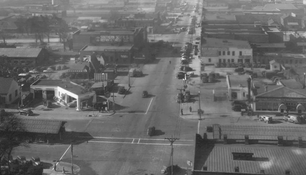
Development within the latter half of the 19th century and into the early 20th century picked up where earlier energies had left off – the outlook for the district remained that of a light-industrial area where greater numbers of railroad tracks brought goods and people to and from the city. A burgeoning textile mill presence within the city made its mark on the district with the completion of the Columbia Mills Building, destined to be the world’s first fully electrically power facility of its kind. Greater numbers of masonry structures replaced earlier wood buildings, revealing both an attempt at heightened fire safety as well as a greater prosperity from earlier years. By World War II, these decades-old buildings were home to numerous businesses, such as that of Gervais Street’s Seaboard Café, some of whose patrons and employees are shown here.
Well into the early 1980s, the Vista’s light industrial and mercantile character remained largely unchanged. However, twenty years earlier much of its residential life had been erased through Fight Blight programs instigated by national trends in urban renewal. Totally lost was the almost exclusively African-American neighborhood known as Ward One, whose modest houses, stores, schools and churches fell for the construction of such buildings as the Carolina Coliseum in 1968. The new view by city planners was this district that lay within the shadow of the State House was ripe for redevelopment – a vision that would change its landscape within the next generation.
Fast forward three decades from when the intersection of Gervais and Huger streets graced the pages of National Geographic for its dubious distinction as one of the worst urban environments in the nation. Today, what modern-day visionaries deemed the Congaree Vista boasts a mixture of historically significant buildings with architecturally sympathetic re-development and infill projects that have resulted in loft, apartment, and townhouse residences, restaurants and bars, specialty shops and offices. Ensuring that culturally, historically and architecturally significant aspects of the district are protected, the City of Columbia established the Congaree Vista as an architectural conservation district. Meanwhile, the area carries another, albeit more obscure moniker –the West Gervais Street Historic District – following its listing in the National Register of Historic Places.
The outlook for the Congaree Vista today is positive and one filled with expectation – expectations of unique dining, entertainment, shopping and living experience within its boundaries; expectations of further new structures and investment blending with old; and expectations of further development to continuing through the construction of new hotels and residences designed to entice new residents and visitors into the capital city. Concurrent with this contemporary interest in what is one of Columbia’s most dynamic urban landscapes is interest in preserving the memories of those persons who and the events that made the district what it was for generations, most recently manifesting itself in historical wayside signage and a walking tour brochure, produced by Historic Columbia Foundation and sponsored by the Congaree Vista Guild and key businesses.